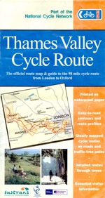
Thames Valley Cycle Route from Reading to London
A varied, mainly flat, route, with a mix of river paths, rolling parkland, canopied woodland tracks and interminably boring carriageway footpaths. Mostly well signposted, although saved by the GPS on my iPhone on more than one occasion.
Ride stats
- 68 miles (Emmer Green, Reading to Putney Bridge, London)
- Mostly flat route, primarily using quiet roads, canal paths and wooded tracks, although also a few busier roads and shared pathways
- Used Mountain bike, but could have done the ride on any sturdy bike (not really suitable for out and out racers)
- Weather was perfect (sunny with a gentle breeze)
- About 7 hours cycling, excluding a stop for lunch in Windsor
- Average speed about 10 miles per hour (although considerably slower towards the end)
- Sunday 3 July 2011
More detail about the route can be found in two sections: Reading to Richmond Park and Richmond Park to Putney Bridge. (Two sections because the battery in my Garmin Edge ran out. The last few miles were recorded using the Cyclemeter app on my iPhone).
The motivation for the ride was a rash commitment to friends that I would ride the Dunwich Dynamo this year (in two weeks time, on 16/17 July), coupled with the knowledge that, up to that point, I had done precious little preparation. Could I rely on the residual fitness of having regularly cycled the 5 miles to and from work until earlier in the year to see me through? This weekend was to be the test.
The original plan had been to cycle from London to Reading on the Friday, attend a barbecue on the Saturday and then cycle back on the Sunday. The plan almost worked. Unfortunately I completely misjudged the time I would need to cycle the full route, and agreed an unachievable deadline (on the basis of my relaxed departure time) to arrive in Reading to child sit for a friend who wanted to go to a college reunion. The happy ending is that it was quite easy to cut the outward journey short and catch a train from Staines to Reading, and so rescue the friendship for another day. (Route map East Dulwich to Staines)

From Putney Bridge, the route follows the Sustrans ‘Thames Valley Cycle Route’ from London to Oxford. To get to the start from East Dulwich on the Friday I followed a route generated using the CycleStreets route planning site, which I mostly managed to follow. It was quite effective in avoiding main roads, but felt like it involved a lot of twists and turns. On the way back I was too tired for backstreet navigation so opted to use the busier, but more direct, main roads back to East Dulwich.
Okay, enough preamble! Below is a brief outline of the route, high points, low points and some overall reflections.
Finding the way
Although I knew that the route would follow signs for NCN routes 4 and 5, as belt and braces, I also took OS Landranger maps 176 and 175 and downloaded the National Cycle Network app for my iPhone! The latter came in useful on a couple of occasions when I lost track of the NCN signage, helping work out whether I had gone astray or just missed the latest sign. The app itself feels like a ‘work in progress’. Also, it is not much use when signal is poor (as quite often happens with Orange out of towns and cities).
Once out of Reading and its suburbs, the route quick settles in to a pattern of quiet roads and wooded tracks. Bray was the first place I remember losing my way – going straight ahead when I should have turned left at the town square. The next was Windsor Park, where all signage seemed to disappear (or perhaps there is a Byelaw about non-Royal signage). However, the most confusing signage was in Chertsey. I ended up improvising to pick up the route on the way to Reading. But after a few false starts, managed to find the recommended route on the way back to London. However, still not completely sure I wouldn’t get lost again. Next time I’ll take some photos of the route.
One of the reasons for mentioning the points at which I got lost due to missing or confusing signage is that for most of the route I had no problems both finding and following the NCN signs. It is also clear that in some places the route has been well integrated into the local network of cycle paths, which are well used and maintained.
Refreshments

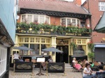
Only made one substantial stop, for lunch in Windsor at The Carpenters Arms.
High points
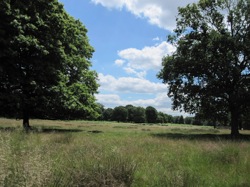
Probably the high point for me (on the route out) was Richmond Park – I hadn’t realised its size, despite being so close to London. On the way back from Reading, the high point was the variety of cycling: river banks, woodland tracks, country roads, cycle paths and suburban streets. Plus making it home: tired but satisfied that I could attempt the Dunwich Dynamo.
Low points
Low points were definitely the frustration of getting lost (and the immediate post mortem of ‘was it me or was it the signage?’) and the, sometimes quite substantial, stretches of cycling along shared pathways beside busy roads.
Overall reflections
A satisfying ride. Decent distance and a mix of surroundings. Also, for me, reassurance that I wasn’t unrealistic to think I could attempt, and complete, the Dunwich Dynamo.

Written up 26 July 2011
- « Previous Page
- 1
- 2
- 3
- 4
- …
- 7
- Next Page »

